by
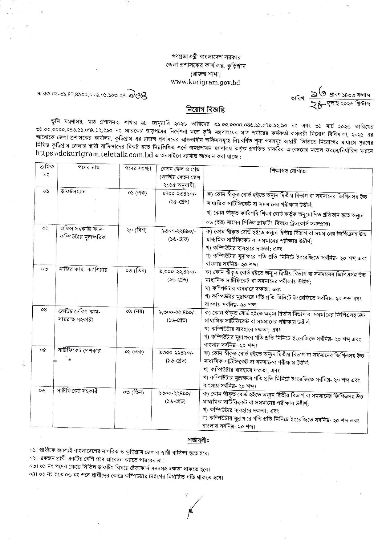
Company Name : Civil Surgeon Office, Kurigram
Website : https://cs.kurigram.gov.bd
Facebook Page
Wikipedia
Download Form
Online Apply
Source: Online
Date of the Circular: 28/07/2026
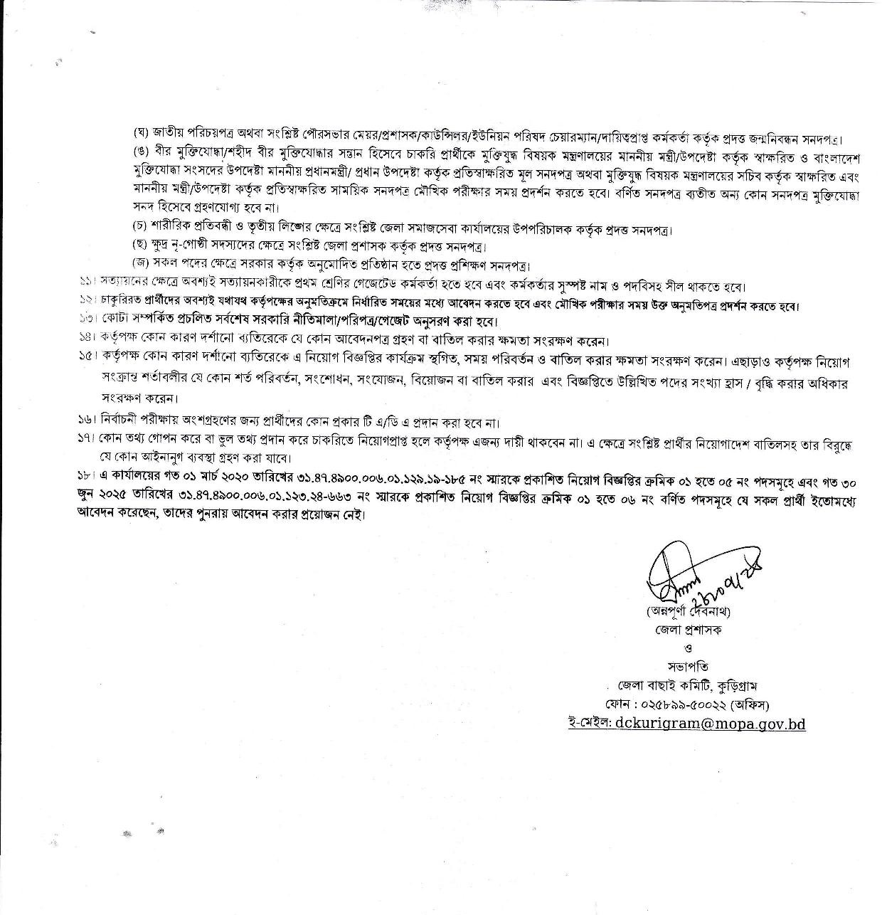
Last Date of Application: 02/09/2026
Total Post : 37
Kurigram District, Bangladesh: History, Geography, Upazilas, Rivers, Tourist Attractions and Culture
Kurigram is an important border district in northern Bangladesh. Known for its rivers, chars, agricultural landscape, historical sites, folk culture and rural lifestyle, the district has a distinctive identity within Rangpur Division.
According to official district information, Kurigram is a border district with an area of approximately 2,245 square kilometers. Its geography is characterized by riverine plains and extensive char areas.
Where is Kurigram District Located?
Kurigram is located in northern Bangladesh. It borders India’s Cooch Behar area to the north, Gaibandha District to the south, Assam and Meghalaya areas of India to the east, and Lalmonirhat and Rangpur districts to the west.
The district has an international border of approximately 278.28 kilometers, according to official geographical information.
Kurigram’s landscape is largely shaped by rivers, fertile alluvial plains and char areas.
History of Kurigram District
Kurigram has a long and diverse history. The official district history describes the development of the region through centuries of settlement, migration, political changes, river erosion and reconstruction. Rivers such as the Brahmaputra, Dharla, Teesta, Dudhkumar and Phulkumar have played an important role in shaping the area.
During British rule, the area was administered through several thanas. According to the official district history, the Kurigram subdivision was established on April 22, 1875. At that time, eight thanas were included in the subdivision.
Kurigram later became a district during the administrative reorganization of Bangladesh. Official district information states that Kurigram was upgraded from a subdivision to a district in 1984.
Area of Kurigram District
The official geographical information page lists the area of Kurigram as approximately 2,245.04 square kilometers.
Because of its riverine geography, the landscape of Kurigram is continuously influenced by rivers, seasonal flooding and the formation and disappearance of char lands.
Upazilas of Kurigram District
Kurigram currently has nine upazilas. They are:
- Kurigram Sadar
- Ulipur
- Nageshwari
- Bhurungamari
- Phulbari
- Rajarhat
- Chilmari
- Rowmari
- Char Rajibpur
Each upazila has its own local history, markets, agricultural activities, cultural traditions and natural features.
Major Rivers of Kurigram
Kurigram is strongly associated with rivers. Official geographical information identifies the Brahmaputra, Dharla, Teesta, Dudhkumar, Phulkumar, Sonabhari, Jinjiram, Gangadhar and several other rivers flowing through or around the district.
These rivers are important for agriculture, fisheries, transportation and local livelihoods. At the same time, river erosion and flooding remain significant challenges for many communities.
Char Areas of Kurigram
Char lands are one of the most distinctive geographical features of Kurigram. New chars can emerge as rivers deposit sediment, while existing areas may change because of erosion and shifting river channels.
Many people living in char areas depend on agriculture, livestock, fishing and small-scale businesses. Their lifestyles are closely connected to seasonal changes in the rivers.
Tourist Attractions in Kurigram
Kurigram has a mixture of natural, historical and religious attractions. The official district tourism list includes Chilmari Port and several historical sites.
Chilmari Port
Chilmari Port is one of the best-known places in Kurigram. According to official information, it is located in Ramna Union of Chilmari Upazila on the bank of the Brahmaputra River. It is approximately 35 kilometers south of Kurigram district headquarters.
The port and the Brahmaputra have historical and economic importance. The riverside environment also makes the area interesting for visitors.
Dolmoncho Temple
Dolmoncho Temple is located in Dhamshreni Union of Ulipur Upazila. Official information places it around three kilometers east of Ulipur Upazila headquarters. The old temple is now in a deteriorated condition, while several other historic temples are located nearby.
Chandi Temple
Chandi Temple, located in Dhamshreni Union of Ulipur Upazila, is another historical religious site listed by the Kurigram district administration.
Chandamari Mosque
Chandamari Mosque is located in Rajarhat Upazila and is included among Kurigram’s notable historical sites in the official district tourism information.
Historical Monuments of Kurigram
Kurigram has several old monuments and archaeological remains. Official district information mentions the remains of old mosques, historic zamindar houses, temples and other structures.
Notable examples include remains of a Mughal-era mosque near Nayarhat, an old mosque near Pateshwari Bazar in Bhurungamari, Joymonir Zamindar House, the abandoned zamindar house and temple at Naodanga, remains of the Panga Rajbari and Kali Siddheshwari Temple in Ulipur.
These sites provide valuable insight into the region’s religious, architectural and social history.
Culture and Traditions of Kurigram
Kurigram has a rich folk and rural cultural tradition. Traditional fairs, religious festivals, folk activities and community gatherings remain important parts of local life.
The district’s official historical information mentions several traditional fairs, including the Chilmari Ashtami Mela, Sindurmati Mela, Madaikhali Mela, Masankura Mela, Dashahara Mela, Siddheshwari Mela, Kali Mela and Gazi Mela.
These events are not only associated with commerce but also provide opportunities for community interaction and cultural expression.
Kurigram and Literature
Kurigram is also connected with Bangladeshi literature. Government information identifies the district as the birthplace of renowned Bangladeshi writer Syed Shamsul Haq.
This literary connection adds another important dimension to Kurigram’s cultural identity.
Economy of Kurigram
Agriculture plays a major role in the economy of Kurigram. The district’s fertile alluvial land and char areas support various agricultural activities.
Rice, maize, vegetables, livestock and other agricultural products contribute to rural livelihoods. Local markets, small businesses, fisheries and river-related economic activities are also important.
Life in Kurigram
The lives of people in Kurigram are closely connected to nature. Rivers, agricultural land, char areas and rural markets play an important role in the social and economic life of local communities.
Flooding and river erosion can create serious difficulties, but local communities have developed different ways of adapting to the changing environment.
Why Visit Kurigram?
Kurigram can be an interesting destination for people who want to experience the rivers, rural landscapes, historical monuments and traditional culture of northern Bangladesh.
The riverside environment of Chilmari, historic mosques and temples, old zamindar-house remains and rural lifestyle offer visitors a different experience from the country’s major urban tourist destinations.
Travelers should check current transportation information and local conditions before visiting any specific location.
Official Information About Kurigram District
The official Kurigram district website provides information about the district’s history, geography, upazilas, heritage, tourist attractions and administrative services.
The Bangladesh National Portal also lists Kurigram as one of the districts under Rangpur Division.
Frequently Asked Questions About Kurigram
Which division is Kurigram in?
Kurigram is part of Rangpur Division in Bangladesh.
How many upazilas are there in Kurigram?
There are nine upazilas in Kurigram District.
What are the major rivers of Kurigram?
The Brahmaputra, Dharla, Teesta, Dudhkumar and Phulkumar are among the major rivers associated with Kurigram.
What are some tourist attractions in Kurigram?
Chilmari Port, Dolmoncho Temple, Chandi Temple and Chandamari Mosque are among the notable places listed in official district information.
When did Kurigram become a district?
According to the official district history, Kurigram was upgraded from a subdivision to a district in 1984.
Conclusion
Kurigram is much more than an administrative district. Its rivers, chars, agriculture, history, literature, traditional fairs and rural lifestyle give it a distinctive identity in northern Bangladesh.
For updated information about Kurigram’s administration, tourism, local services and historical sites, readers should consult the official Kurigram district website and the Bangladesh National Portal.
কুড়িগ্রাম জেলা: ইতিহাস, ভৌগোলিক পরিচিতি, উপজেলা, নদ-নদী, দর্শনীয় স্থান ও সংস্কৃতি
বাংলাদেশের উত্তরাঞ্চলের সীমান্তবর্তী একটি গুরুত্বপূর্ণ জেলা কুড়িগ্রাম। নদী, চর, সবুজ প্রকৃতি, ঐতিহাসিক স্থাপনা, গ্রামীণ জীবনধারা ও সমৃদ্ধ লোকসংস্কৃতির কারণে জেলার রয়েছে আলাদা পরিচিতি। কুড়িগ্রাম রংপুর বিভাগের অন্তর্ভুক্ত এবং ভারতের পশ্চিমবঙ্গ, আসাম ও মেঘালয় অঞ্চলের সীমান্তের কাছাকাছি অবস্থিত। সরকারি জেলা তথ্য অনুযায়ী, কুড়িগ্রামের আয়তন প্রায় ২,২৪৫ বর্গকিলোমিটার এবং জেলার ভৌগোলিক বৈশিষ্ট্যের বড় অংশ জুড়ে রয়েছে নদী ও চরাঞ্চল।
কুড়িগ্রাম জেলা কোথায় অবস্থিত?
কুড়িগ্রাম বাংলাদেশের উত্তরাঞ্চলে অবস্থিত একটি সীমান্তবর্তী জেলা। এর উত্তরে ভারতের পশ্চিমবঙ্গের কুচবিহার অঞ্চল, দক্ষিণে গাইবান্ধা, পূর্বে ভারতের আসাম ও মেঘালয় এবং পশ্চিমে লালমনিরহাট ও রংপুর জেলা অবস্থিত। জেলার আন্তর্জাতিক সীমান্তরেখার দৈর্ঘ্য সরকারি তথ্য অনুযায়ী প্রায় ২৭৮.২৮ কিলোমিটার।
নদীবেষ্টিত সমতল ভূমি এবং চরাঞ্চল কুড়িগ্রামের ভূপ্রকৃতির অন্যতম বৈশিষ্ট্য। ফলে বর্ষাকালে নদীর পানি ও চরাঞ্চলের পরিবর্তন এখানকার মানুষের জীবনযাত্রা ও অর্থনীতিতে গুরুত্বপূর্ণ প্রভাব ফেলে।
কুড়িগ্রাম জেলার ইতিহাস
কুড়িগ্রামের ইতিহাস দীর্ঘ ও বৈচিত্র্যময়। জেলা প্রশাসনের তথ্য অনুযায়ী, এ অঞ্চলের ইতিহাসের সঙ্গে ব্রহ্মপুত্র, ধরলা, তিস্তা, দুধকুমার ও ফুলকুমারসহ বিভিন্ন নদীর ভাঙা-গড়া ও জনজীবনের পরিবর্তন ঘনিষ্ঠভাবে যুক্ত।
ব্রিটিশ শাসনামলে কুড়িগ্রাম অঞ্চল প্রশাসনিকভাবে বিভিন্ন থানায় বিভক্ত ছিল। সরকারি জেলা ইতিহাস অনুযায়ী, ১৮৭৫ সালের ২২ এপ্রিল কুড়িগ্রাম মহকুমা প্রতিষ্ঠিত হয়। সে সময় কুড়িগ্রাম, লালমনিরহাট, উলিপুর, চিলমারী, রৌমারী, নাগেশ্বরী, ভূরুঙ্গামারী ও ফুলবাড়ী—এই আটটি থানা মহকুমার অন্তর্ভুক্ত ছিল।
পরবর্তীতে প্রশাসনিক পুনর্গঠনের মাধ্যমে কুড়িগ্রাম জেলা হিসেবে প্রতিষ্ঠা লাভ করে। সরকারি জেলা তথ্য অনুযায়ী, ১৯৮৪ সালে কুড়িগ্রাম মহকুমা জেলায় উন্নীত হয়।
কুড়িগ্রাম জেলার আয়তন
সরকারি জেলা পোর্টালের বিভিন্ন তথ্যে আয়তনের পরিসংখ্যানে সামান্য ভিন্নতা দেখা যায়। জেলা প্রশাসনের ভৌগোলিক পরিচিতি পেজে আয়তন ২,২৪৫.০৪ বর্গকিলোমিটার উল্লেখ করা হয়েছে।
জেলার বড় একটি অংশ নদী ও চরভূমি হওয়ায় কুড়িগ্রামের ভূপ্রকৃতি অন্যান্য অনেক জেলার তুলনায় স্বতন্ত্র।
কুড়িগ্রাম জেলার উপজেলা
বর্তমানে কুড়িগ্রাম জেলায় মোট ৯টি উপজেলা রয়েছে। এগুলো হলো—
- কুড়িগ্রাম সদর উপজেলা
- উলিপুর উপজেলা
- নাগেশ্বরী উপজেলা
- ভূরুঙ্গামারী উপজেলা
- ফুলবাড়ী উপজেলা
- রাজারহাট উপজেলা
- চিলমারী উপজেলা
- রৌমারী উপজেলা
- চর রাজিবপুর উপজেলা
প্রতিটি উপজেলার রয়েছে নিজস্ব ইতিহাস, নদী, বাজার, শিক্ষা প্রতিষ্ঠান, কৃষি ও সাংস্কৃতিক বৈশিষ্ট্য।
কুড়িগ্রামের প্রধান নদ-নদী
কুড়িগ্রামকে নদীর জেলা বললেও ভুল হবে না। সরকারি ভৌগোলিক তথ্যে ব্রহ্মপুত্র, ধরলা, তিস্তা, দুধকুমার, ফুলকুমার, সোনাভরি, জিঞ্জিরাম, গঙ্গাধর ও হলহলিয়াসহ বেশ কয়েকটি নদীর কথা উল্লেখ করা হয়েছে।
নদীগুলো জেলার কৃষি, যোগাযোগ, মৎস্যসম্পদ ও মানুষের জীবনযাত্রার সঙ্গে গভীরভাবে সম্পর্কিত। একই সঙ্গে নদীভাঙন ও বন্যা কুড়িগ্রামের অনেক এলাকার জন্য দীর্ঘদিনের চ্যালেঞ্জ।
কুড়িগ্রামের চরাঞ্চল
কুড়িগ্রামের অন্যতম স্বতন্ত্র বৈশিষ্ট্য হলো চরাঞ্চল। নদীর গতিপথ ও পলি জমার ফলে বিভিন্ন সময়ে নতুন চর সৃষ্টি হয় এবং পুরোনো চর পরিবর্তিত হয়।
চরাঞ্চলের মানুষ সাধারণত কৃষিকাজ, পশুপালন, মৎস্য আহরণ ও বিভিন্ন ছোট ব্যবসার ওপর নির্ভরশীল। নদী ও চরভূমির কারণে এখানকার জীবনযাত্রায় প্রকৃতির প্রভাব অত্যন্ত বেশি।
কুড়িগ্রামের দর্শনীয় স্থান
কুড়িগ্রামে প্রকৃতি ও ইতিহাস—দুই ধরনের দর্শনীয় স্থান রয়েছে। জেলা প্রশাসনের পর্যটন তালিকায় চিলমারী বন্দরসহ বিভিন্ন স্থান অন্তর্ভুক্ত রয়েছে।
চিলমারী বন্দর
চিলমারী বন্দর কুড়িগ্রামের অন্যতম পরিচিত স্থান। সরকারি তথ্য অনুযায়ী এটি চিলমারী উপজেলার রমনা ইউনিয়নে ব্রহ্মপুত্র নদীর তীরে অবস্থিত এবং কুড়িগ্রাম জেলা সদর থেকে প্রায় ৩৫ কিলোমিটার দক্ষিণে।
ব্রহ্মপুত্র নদ ও চিলমারী বন্দরের ঐতিহাসিক ও অর্থনৈতিক গুরুত্ব রয়েছে। নদীর তীরবর্তী পরিবেশ দর্শনার্থীদের জন্যও আকর্ষণীয়।
দোলমঞ্চ মন্দির
উলিপুর উপজেলার ধামশ্রেণী ইউনিয়নে অবস্থিত দোলমঞ্চ মন্দির কুড়িগ্রামের একটি ঐতিহাসিক স্থাপনা। সরকারি তথ্য অনুযায়ী, এটি উলিপুর উপজেলা সদর থেকে প্রায় ৩ কিলোমিটার পূর্বদিকে অবস্থিত। মন্দিরটি বর্তমানে পুরোনো ও ভগ্নদশায় রয়েছে এবং আশপাশে আরও কয়েকটি ঐতিহাসিক মন্দিরের নিদর্শন রয়েছে।
চণ্ডী মন্দির
উলিপুর উপজেলার ধামশ্রেণী ইউনিয়নে চণ্ডী মন্দির অবস্থিত। এটি কুড়িগ্রামের ঐতিহাসিক ও ধর্মীয় স্থাপনাগুলোর একটি।
চান্দামারী মসজিদ
রাজারহাট উপজেলায় অবস্থিত চান্দামারী মসজিদও জেলার উল্লেখযোগ্য ঐতিহাসিক স্থাপনার মধ্যে রয়েছে। জেলা প্রশাসনের পর্যটন তালিকায় এ স্থানের উল্লেখ রয়েছে।
কুড়িগ্রামের ঐতিহাসিক পুরাকীর্তি
কুড়িগ্রামে বিভিন্ন সময়ের পুরোনো স্থাপনা ও প্রত্নতাত্ত্বিক নিদর্শন রয়েছে। সরকারি জেলা তথ্য অনুযায়ী, নয়ারহাটের মসজিদের ধ্বংসাবশেষ, ভূরুঙ্গামারীর পুরোনো মসজিদ, জয়মনির জমিদারবাড়ি, নাওডাঙ্গার পরিত্যক্ত জমিদারবাড়ি ও মন্দির, পাঙ্গা রাজবাড়ির ধ্বংসাবশেষ এবং উলিপুরের কালী সিদ্ধেশ্বরী মন্দির উল্লেখযোগ্য ঐতিহাসিক নিদর্শনের মধ্যে রয়েছে।
এসব স্থাপনা কুড়িগ্রামের অতীত ইতিহাস, জমিদারি সংস্কৃতি ও ধর্মীয় ঐতিহ্যের বিভিন্ন দিক তুলে ধরে।
কুড়িগ্রামের সংস্কৃতি ও ঐতিহ্য
কুড়িগ্রামের লোকজ সংস্কৃতি অত্যন্ত বৈচিত্র্যময়। জেলার বিভিন্ন এলাকায় ঐতিহ্যবাহী মেলা, ধর্মীয় অনুষ্ঠান, লোকসংগীত ও গ্রামীণ সাংস্কৃতিক আয়োজনের প্রচলন রয়েছে।
জেলা প্রশাসনের ইতিহাস ও ঐতিহ্যবিষয়ক তথ্যে চিলমারীর অষ্টমীর মেলা, সিঁন্দুরমতির মেলা, মাদাইখালের মেলা, মাসানকুড়ার মেলা, দশহরার মেলা, চেংরার মেলা, সিদ্ধেশ্বরীর মেলা, কালীর মেলা ও গাজীর মেলাসহ বিভিন্ন মেলার উল্লেখ পাওয়া যায়।
কুড়িগ্রাম ও সাহিত্য
কুড়িগ্রাম বাংলাদেশের সাহিত্যাঙ্গনের সঙ্গেও যুক্ত। সরকারি জেলা-সংক্রান্ত তথ্য ও স্থানীয় সরকারি পোর্টালে সব্যসাচী লেখক সৈয়দ শামসুল হকের জন্মভূমি হিসেবে কুড়িগ্রামের উল্লেখ রয়েছে।
এ কারণে সাহিত্যপ্রেমীদের কাছেও কুড়িগ্রামের আলাদা সাংস্কৃতিক গুরুত্ব রয়েছে।
কুড়িগ্রামের অর্থনীতি
কুড়িগ্রামের অর্থনীতিতে কৃষির ভূমিকা গুরুত্বপূর্ণ। নদীবেষ্টিত সমতল ভূমি ও চরাঞ্চলের কারণে কৃষিকাজ এখানকার বহু মানুষের জীবিকার অন্যতম উৎস।
ধান, ভুট্টা, শাকসবজি, বিভিন্ন কৃষিপণ্য ও পশুপালন গ্রামীণ অর্থনীতির অংশ। পাশাপাশি হাট-বাজার, ক্ষুদ্র ব্যবসা, নদীকেন্দ্রিক কর্মকাণ্ড ও স্থানীয় বাণিজ্যও অর্থনীতিতে ভূমিকা রাখে।
কুড়িগ্রামের মানুষের জীবনযাত্রা
কুড়িগ্রামের মানুষের জীবন প্রকৃতির সঙ্গে নিবিড়ভাবে সম্পর্কিত। নদী, চর, কৃষিজমি ও গ্রামীণ বাজারকে কেন্দ্র করে এখানকার সামাজিক ও অর্থনৈতিক জীবন গড়ে উঠেছে।
বিশেষ করে নদীভাঙন ও বন্যার মতো প্রাকৃতিক দুর্যোগ মানুষের জীবনযাত্রায় প্রভাব ফেললেও স্থানীয় মানুষের অভিযোজন ক্ষমতা ও পরিশ্রম কুড়িগ্রামের সামাজিক জীবনের অন্যতম বৈশিষ্ট্য।
কুড়িগ্রাম কেন ভ্রমণের জন্য আকর্ষণীয়?
যারা বাংলাদেশের গ্রামীণ প্রকৃতি, নদী, চর, ঐতিহাসিক স্থাপনা ও স্থানীয় সংস্কৃতি দেখতে চান, তাদের জন্য কুড়িগ্রাম আকর্ষণীয় হতে পারে।
চিলমারী বন্দরের নদীর পরিবেশ, ঐতিহাসিক মসজিদ-মন্দির, পুরোনো জমিদারবাড়ির নিদর্শন এবং গ্রামীণ জীবন কুড়িগ্রামের ভ্রমণ অভিজ্ঞতাকে বৈচিত্র্যময় করে।
ভ্রমণের আগে সংশ্লিষ্ট সরকারি ওয়েবসাইটে স্থানটির বর্তমান অবস্থা, যোগাযোগ ব্যবস্থা ও স্থানীয় নির্দেশনা যাচাই করা ভালো।
কুড়িগ্রাম জেলার সরকারি তথ্য কোথায় পাওয়া যাবে?
কুড়িগ্রাম জেলার প্রশাসনিক তথ্য, ইতিহাস, ঐতিহ্য, উপজেলার তালিকা, পর্যটন স্থান ও অন্যান্য তথ্যের জন্য জেলা প্রশাসনের সরকারি ওয়েবসাইট kurigram.gov.bd ব্যবহার করা যেতে পারে।
বাংলাদেশ জাতীয় তথ্য বাতায়নেও কুড়িগ্রামকে রংপুর বিভাগের একটি জেলা হিসেবে তালিকাভুক্ত করা হয়েছে।
কুড়িগ্রাম জেলা সম্পর্কে FAQ
কুড়িগ্রাম কোন বিভাগের অন্তর্ভুক্ত?
কুড়িগ্রাম রংপুর বিভাগের অন্তর্ভুক্ত একটি জেলা।
কুড়িগ্রামে কয়টি উপজেলা?
কুড়িগ্রাম জেলায় মোট ৯টি উপজেলা রয়েছে।
কুড়িগ্রামের প্রধান নদী কোনগুলো?
ব্রহ্মপুত্র, ধরলা, তিস্তা, দুধকুমার ও ফুলকুমারসহ বিভিন্ন নদী কুড়িগ্রামের মধ্য দিয়ে প্রবাহিত হয়েছে।
কুড়িগ্রামের বিখ্যাত দর্শনীয় স্থান কী?
চিলমারী বন্দর, দোলমঞ্চ মন্দির, চণ্ডী মন্দির ও চান্দামারী মসজিদসহ বিভিন্ন ঐতিহাসিক ও প্রাকৃতিক স্থান কুড়িগ্রামে রয়েছে।
কুড়িগ্রাম কবে জেলা হয়?
সরকারি জেলা ইতিহাস অনুযায়ী, ১৯৮৪ সালে কুড়িগ্রাম মহকুমা থেকে জেলায় উন্নীত হয়।
উপসংহার
কুড়িগ্রাম শুধু একটি প্রশাসনিক জেলা নয়; নদী, চর, কৃষি, ইতিহাস, সাহিত্য, লোকসংস্কৃতি ও মানুষের সংগ্রামী জীবনধারার সমন্বয়ে এটি বাংলাদেশের উত্তরাঞ্চলের একটি স্বতন্ত্র জনপদ। দীর্ঘ ইতিহাস, ব্রহ্মপুত্র-ধরলা-তিস্তাসহ বিভিন্ন নদী এবং ঐতিহাসিক স্থাপনা কুড়িগ্রামকে বিশেষ বৈশিষ্ট্য দিয়েছে।
কুড়িগ্রাম সম্পর্কে আরও নির্ভরযোগ্য ও হালনাগাদ তথ্য জানতে জেলা প্রশাসনের সরকারি ওয়েবসাইট এবং বাংলাদেশ জাতীয় তথ্য বাতায়ন অনুসরণ করা সবচেয়ে ভালো।